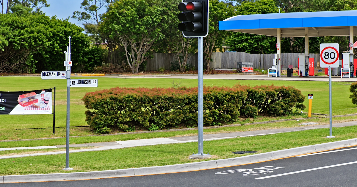
A missing eastbound bus stop on Johnson Road in Heathwood leaves students and commuters without a corresponding boarding point near Dickman Road, and a petition notes that one alternative is a bridge with no footpath.
The petition, posted on 28 August 2026 and open until 17 November, seeks a new eastbound stop opposite existing stop 320037. It identifies students travelling to Pallara State School and residents heading towards Grand Plaza among those affected.
One Direction Has a Stop, the Other Does Not
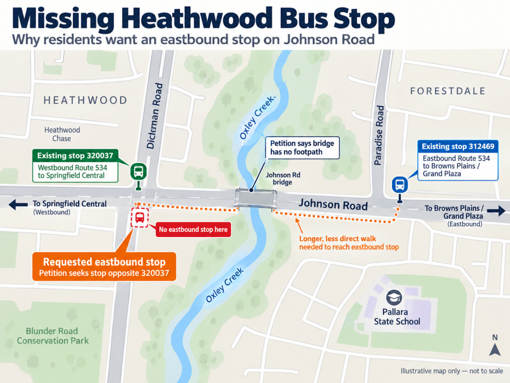
Translink records show stop 320037 at Johnson Road near Dickman Road serves Route 534 towards Springfield Central. The petition says there is no corresponding eastbound stop at the same location.
Passengers travelling towards Browns Plains can instead board Route 534 at Johnson Road near Paradise Road, where stop 312469 serves eastbound services.
On westbound Route 534 services, the Paradise Road and Dickman Road stops are scheduled about one minute apart. The petition says the walking options between the two sides of Johnson Road are less direct.
Petition Points to a Bridge Without a Footpath
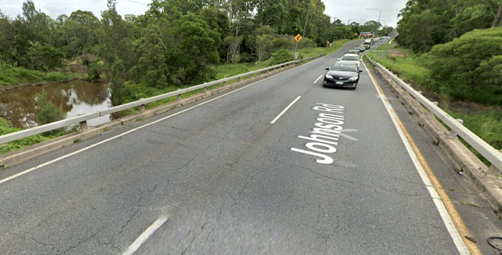
The petition says Forestdale residents travelling eastbound may need to arrange other transport, travel to another stop and double back, or cross the Johnson Road bridge. Yet the bridge has no footpath.
No footpath on Johnson Bridge Photo Credit: Google Maps
Petitioners are asking for an eastbound stop opposite 320037 and any pedestrian safety works needed at the site. They also state that land is available near the existing stop and that a footpath is already present in the vicinity.
Heathwood Already Sits on the School Bus Network
Public transport links between Heathwood and Pallara State School already operate elsewhere in the network.
Translink lists Route 803 as a school service between Heathwood Estate and Pallara State School, while Route 804 runs between Pallara and the school via Heathwood. Both are designated school-only services.
Pallara State School operates under a School Enrolment Management Plan because of enrolment capacity and growth. The plan, gazetted on 4 September 2026, gives the school a maximum enrolment capacity of 1,607 students and limits out-of-catchment enrolments where needed to preserve places for local children.
Walking Access Is Part of Bus Stop Infrastructure
Published Transport and Main Roads material identifies pedestrian connections as part of accessible bus stop infrastructure.
Under its Passenger Transport Accessible Infrastructure Program, TMR says funding to councils can include footpath connections between bus stops and passengers’ onward journeys, along with boarding platforms, signage and other accessibility works.
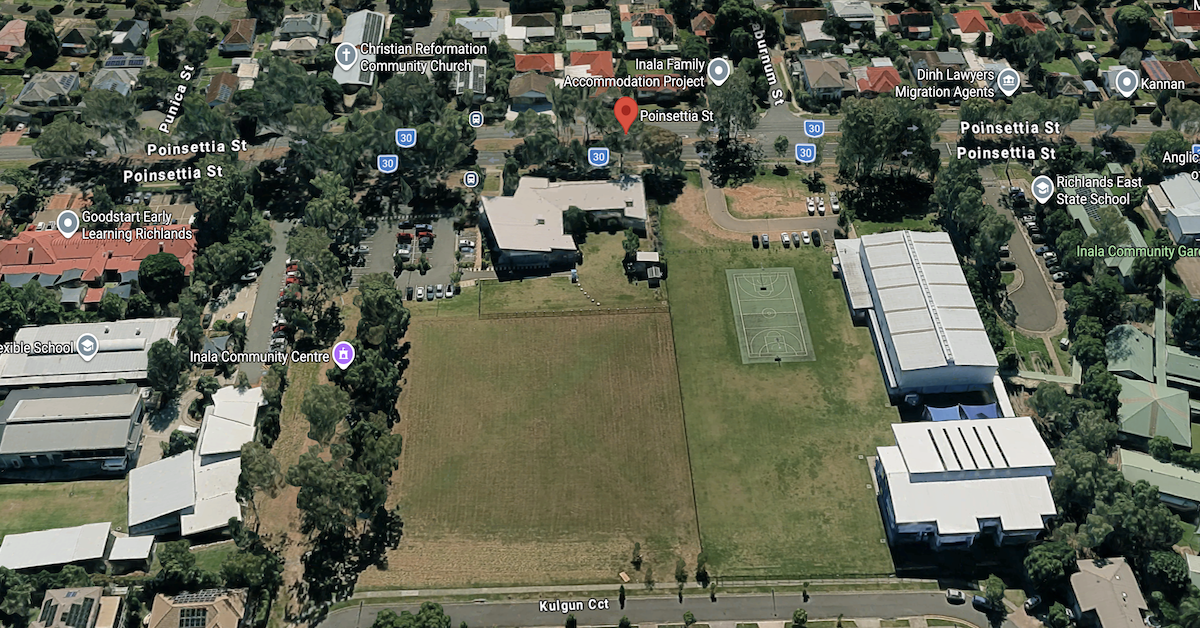
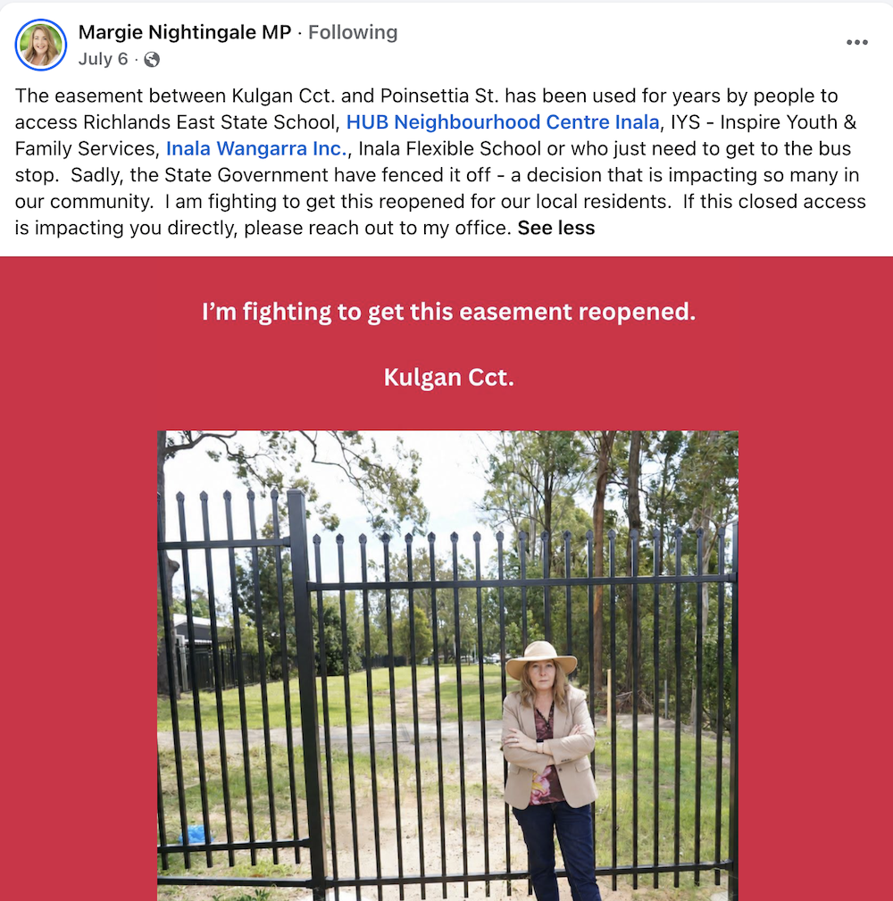
For years, residents used a pedestrian connection between Kulgan Circuit and Poinsettia Street to reach nearby schools, community organisations and public transport. The route is now blocked by fencing, removing a direct pedestrian connection through the area.
The closure has left some pedestrians taking longer, less convenient routes. It has also raised questions about who controls the accessway and whether a direct pedestrian connection can be restored.
Poinsettia Street: A Vital Community Hub
The closure has drawn attention because several schools, community organisations and public transport services are concentrated along Poinsettia Street.
Richlands East State School is at 99 Poinsettia Street, while Inala Flexible School operates from 67 Poinsettia Street. Inala Wangarra also lists its meeting place in the precinct.
The HUB Neighbourhood Centre Inala is located at 79 Poinsettia Street. In 2016, the Queensland Government allocated funding for a new community centre on what was then department-owned land at that address.
HUB provides practical services and activities including playgroups and public computer and Wi-Fi access. The Queensland Government also lists Inala among locations where Community Connect workers support individuals and families with complex needs.
Public transport forms another part of the local access picture. Translink lists stop 77/59 on Poinsettia Street at Richlands Campus.
Route 101 serves the stop on services towards Oxley station, while Route 122 timetables also show services through the stop towards Garden City.
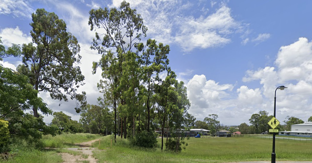
Before the closure Photo Credit: Google Maps
Broader Pedestrian Planning in Inala
The dispute sits against a background of ongoing council planning designed to improve local foot traffic. Brisbane City Council, supported by the Queensland Government’s Walking Grants program, developed the Inala Walking Network Plan. The proposed plan was intended to identify primary and secondary routes connecting everyday destinations and help guide future infrastructure investment around Inala Plaza and the bus station.
While community consultation for the plan closed in November 2024, the strategy does not take an explicit position on the Kulgan Circuit-Poinsettia Street link. Nevertheless, it highlights that direct, safe, and accessible walking connections are already a key planning priority for the broader region.
Unanswered Questions Surrounding the Fence
Despite growing local frustration, the exact reason for the blockage remains unclear. Member for Inala Margie Nightingale has attributed the decision to the State Government, calling for the route to be reopened or for a practical alternative to be established.
However, public records do not clarify which specific agency authorised the fencing, nor whether the decision was driven by safety, land management, or liability concerns.
It also remains unconfirmed whether the long-used pathway ever possessed formal public access rights. While usage data and exact detour distances have not been publicly detailed, the practical impact on foot travellers is evident.
The Search for a Solution
The concentration of education, social support, and public transport along Poinsettia Street explains why the closure of a single neighbourhood pathway has become a pressing issue.
Until the authority responsible for the barrier clarifies its position, residents who rely on the Kulgan Circuit connection are left waiting to see if their direct route will ever be restored.
Construction on the first of two new bus stops on Ritchie Road in Pallara will begin next month. Crews will work between 8pm and 9am, Monday to Saturday, near Hideaway Street to deliver public transport infrastructure to the southern Brisbane suburb.
The announcement follows ongoing community petitions for improved bus access along Ritchie Road. The new stop near Hideaway Street will be the first to proceed to construction, scheduled to commence in June 2026.
Work on a second stop closer to Van Dieren Road is still in the consultation phase, with further planning updates expected in the coming months as design teams finalise utility and corridor requirements.
Years of growth, years of waiting
Pallara remains one of Brisbane’s fastest-growing suburbs, but local public transport options and civic amenities have historically lagged behind residential development approvals. Families moving into newly created estates anticipated future facilities including shops and public transport, though the delivery of these services has taken longer than early planning frameworks suggested.
Translink Route 126 provides Pallara’s primary public transport connection, linking the suburb through Sunnybank Plaza and Altandi Station to the broader network. Previous infrastructure work on Ritchie Road, completed in stages between 2022 and 2023, delivered bus stops near Pallara State School at Falkland Street and Atlantic Place as part of a broader corridor upgrade.
However, dedicated stops along the Hideaway Street and Van Dieren Road sections of the corridor have remained absent until now.
Daily traffic counts document significant pressure on Ritchie Road. The road functions as the primary arterial connector for the suburb, and peak-hour congestion persists because the resident population has grown faster than the surrounding road and transport network.
One stop confirmed, one still in progress
Construction on the first new stop near Hideaway Street is set to begin in June 2026, with works scheduled overnight and in the early morning to reduce disruption to daytime traffic on Ritchie Road.
Project teams are currently consulting stakeholders on the second stop near Van Dieren Road, with a construction timeline yet to be confirmed while design work awaits final utility and corridor clearances.
Together, the two stops will extend the usable bus network along Ritchie Road. The new infrastructure shortens walking distances to Route 126 for the surrounding catchment, dropping the commute down to under 400 metres for nearby estates.
For residents in the southern sections of the suburb, a stop near Van Dieren Road expands accessible public transport coverage to an area previously outside standard walking catchments.
Community concerns
Pallara residents have raised longstanding concerns over inadequate infrastructure, noting that the local road network and public transport services have struggled to keep pace with the suburb’s population growth.
Community advocates have consistently called for investment in Ritchie Road infrastructure, and the confirmation of these two new bus stops follows years of organised resident feedback.
The construction of the first stop begins in June 2026. For the latest updates on Translink bus services in Pallara, visit click here or call 13 12 30.
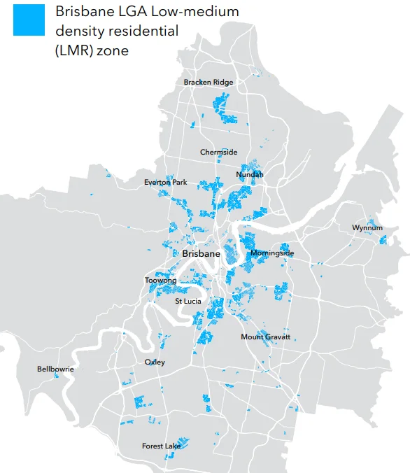
Forest Lake is one of 18 Brisbane suburbs where planning rules for low-medium density residential zones may change under the More Homes, Sooner initiative, but local residents are making clear that their support for new housing hinges on whether schools, roads and public transport can keep pace with any growth the changes deliver.
The proposed changes to the LMR zone affect pockets of Forest Lake close to public transport stops and the Forest Lake Shopping Centre on Forest Lake Boulevard. Community consultation is open until Friday 20 March 2026. Forest Lake residents have delivered a pointed and practical response, cutting through abstract planning language to ask a question local families face every day: what comes first, the homes or the infrastructure to support them?
A Suburb Already Under Pressure
Developers master-planned Forest Lake from the ground up in 1991 as Brisbane’s first purpose-designed community, creating 7,700 house lots, 120 hectares of parks and the 10.9-hectare recreational lake that defines the suburb’s identity. That deliberate design gave Forest Lake its community character, but it also created fixed infrastructure and a fixed school catchment that is now under genuine strain.
Forest Lake State High School introduced an Enrolment Management Plan in August 2025, meaning the school is operating at or near capacity and is now restricting out-of-catchment enrolments. Families already living in Forest Lake say the suburb’s secondary schooling infrastructure cannot currently absorb significant additional enrolments. Community members have raised this directly in response to the More Homes, Sooner proposals, with the concern that more dwellings means more families, and more families means more pressure on schools that are already full.
The transport picture adds to that concern. Forest Lake has no train station within its boundaries. The suburb’s main public transport connections to the city are the Route 100 CityXpress from Forest Lake Shops to the city, and the Routes 460 and 461 via the Centenary Highway and Western Freeway. For the More Homes, Sooner framework to designate areas near bus stops as Key Locations eligible for four-storey development, the frequency and reliability of those services matters enormously to residents who would rely on them.
What Is Being Proposed
The changes focus on Low Medium Density Residential LMR zones, typically located near transport corridors and shopping centres rather than across entire suburbs. The proposal would lift the base building height to three storeys across all LMR land. Properties within 400 metres walking distance of a shopping centre or a bus stop with services at least every 20 minutes during the day would qualify as Key Locations and could rise to four storeys on lots of 800 square metres or more.
Photo Credit: BCC
In Forest Lake, only areas close to high-frequency routes would meet that threshold, while streets served by lower-frequency services would remain subject to the three-storey limit.
Minimum lot sizes would reduce to 120 square metres in some circumstances, enabling small freehold houses and terrace-style homes on compact blocks in well-serviced locations. The proposal would adjust on-site car parking requirements, reducing the requirement for two-bedroom units from two spaces to 1.5 spaces citywide and to 1.2 spaces in Key Locations, reflecting declining car ownership and the significant cost car spaces add to new homes.
Design safeguards are part of the framework, including minimum setbacks from freestanding houses, maximum building footprints and requirements for street tree planting.
Affordability: The Real Question
Beyond the infrastructure debate, Forest Lake residents have raised a point that goes to the heart of why the housing crisis persists regardless of what planning rules say. More dwellings do not automatically mean affordable dwellings. Builders and developers face rising costs for labour, materials and financing, along with the tax embedded in every new build, which pushes the price of new townhouses and compact apartments in established suburban Brisbane beyond the reach of many buyers on typical incomes.
Community members have noted that easing planning controls is only one part of the equation, and that without addressing the underlying cost of construction and the viability gap that affects smaller infill projects, the number of homes actually built as a result of these changes may be far fewer than the headline figures suggest. That concern has some grounding in recent history: new dwelling approvals across Brisbane’s LMR zones fell from around 1,100 homes per year to just 445 in 2023, not because the planning rules prevented development, but because the economics of building did not stack up.
Planning-aware residents view the initiative’s adjustment of car parking requirements as one of the more practical levers, noting that a single basement car space can add up to $82,000 to the cost of a unit. Whether that alone is enough to shift the economics meaningfully is a genuine question the community is raising through this consultation.
How to Have Your Say
Consultation on the More Homes, Sooner draft amendments is open until Friday 20 March 2026. Residents can share feedback online at brisbane.qld.gov.au by searching “More Homes, Sooner”, by emailing strategicplanninghousing@brisbane.qld.gov.au, or by calling 07 3403 8888. Written submissions can be posted to Strategic Planning (More Homes Sooner), Brisbane City Council, GPO Box 1434, Brisbane QLD 4001.
Pallara residents are stepping up their campaign for better public transport, asking for a direct bus service to Brisbane City as the suburb’s population surges and commutes stretch beyond an hour each way.
Over the past few years, Pallara has changed dramatically. Once semi-rural, it’s now a growing community filled with new homes, young families, and busy streets. Yet as the population has surged, public transport has barely budged. Most residents still face a 1-hour and 15-minute commute each way, often involving multiple bus transfers just to get to work or school.
For many, the impact is more than just inconvenience. The extra travel time chips away at family life, adds daily stress, and forces people to rely on cars — contributing to congestion, higher emissions, and parking headaches across the city. It’s a reality that locals say shouldn’t exist in a modern, growing Brisbane suburb.
Voices Rising for Change
A new petition has been lodged and the request is straightforward: extend Route 137 or introduce a new direct bus line that connects Pallara to the city centre. The petition, open until 15 December 2025, has already drawn more than 200 signatures from residents eager for faster, more reliable transport.
Supporters point out that the nearby Willawong Bus Depot makes it easy and cost-effective to add services. They want frequent buses during peak hours and future planning that keeps pace with the suburb’s ongoing growth.
Photo Credit: Neegzistuoja/Wikimedia Commons/CC Attribution-Share Alike 4.0 International
A Longstanding Concern
This isn’t Pallara’s first transport battle. In 2022, locals voiced their frustrations through a Change.org campaign, demanding basic bus services. There were small steps forward, including plans for new stops on routes in the south. But for many, progress has been too slow and too limited.
Now, residents are no longer just asking for any bus — they want a direct, efficient connection to Brisbane City that could save commuters up to an hour a day, reduce traffic, and support Brisbane’s sustainability goals by encouraging more people to leave their cars at home.
Pallara may be one of Brisbane’s fastest-growing suburbs, but sadly, public transport and other infrastructure and amenities have been lagging for years, much to the frustration of its residents.
Residents say that it has been five years since developments in the area were approved. Families were encouraged to move into the newly created suburb of Pallara with the prospects of future facilities including shops and public transport being available to the locals soon. They are, however, yet to see these amenities delivered to their community.
Particularly, Pallara residents have long been campaigning for their own public bus service. A petition launched last year highlighted the concerns of parents over their children’s safety with “so much movement with developments” in the area and the main road being used by motorists to access alternate suburbs.
Recently, Councillor Angela Owen confirmed that there will be six new permanent bus stops that will be built by summer this year in Pallara, following its agreement with the Department of Transport and Main Roads to install a new bus route in this booming suburb.
Three pairs of new bus stops will be built at Pallara by summer, and two of these stops will be installed at Brookbent Road. Another pair will be located at Ritchie Road, near where the old Pallara State School was once situated, whilst the two other stops will be built close to the new Pallara State School.
The current route 126 (Mitchell St, Acacia Ridge East to Zamia St, Sunnybank Plaza) will be realigned and then extended to run along Mains Road and also south to Ritchie Road. This change will provide a bus route to Sunnybank Plaza and CBD connections and even further south to Heathwood.
The Council initially wanted to fast-track the project by installing temporary bus stops but TMR was requiring permanent bus shelters that are federal accessibility and Australian laws compliant before the 126 bus service could be extended.
This was underscored by TMR through a letter sent to Councillor Ryan Murphy, council’s Civic Cabinet Chair for Transport, stating that Translink supported the business case for the amended bus route and is ready to implement the new services subject to the bus stop requirements.
Member for Algester Leeanne Enoch confirmed that Council has agreed to the requirements and plans to deliver at least six bus stops in the interim to facilitate the extension of route 126 bus services to Pallara. Residents are to see some construction activities commencing in the coming months. Other stops are expected to be delivered after the bus services are already in place.